
Hensonville topographic map
Interactive map
Click on the map to display elevation.
About this map
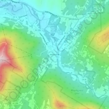
Name: Hensonville topographic map, elevation, terrain.
Average elevation: 585 m
Minimum elevation: 462 m
Maximum elevation: 909 m
Other topographic maps
Click on a map to view its topography, its elevation and its terrain.
Brooksburg
United States > New York > Greene County > Town of Windham
Brooksburg, Town of Windham, Greene County, New York, 12439, United States
Average elevation: 565 m
Maplecrest
United States > New York > Greene County > Town of Windham
Maplecrest, Town of Windham, Greene County, New York, 12454, United States
Average elevation: 625 m
Blackhead
United States > New York > Greene County > Town of Windham
Blackhead, Town of Windham, Greene County, New York, United States
Average elevation: 893 m