
Caramulo topographic map
Interactive map
Click on the map to display elevation.
About this map
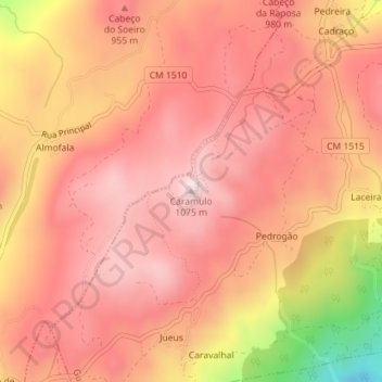
Name: Caramulo topographic map, elevation, terrain.
Location: Caramulo, Tondela, Viseu, 3475-031, Portugal (40.54722 -8.20210 40.54732 -8.20200)
Average elevation: 895 m
Minimum elevation: 532 m
Maximum elevation: 1,045 m
Other topographic maps
Click on a map to view its topography, its elevation and its terrain.
Paranho de Besteiros
Paranho de Besteiros, Caparrosa e Silvares, Tondela, Viseu, 3460-454, Portugal
Average elevation: 458 m
Barragem da Ribeira do Paul
Barragem da Ribeira do Paul, Vilar de Besteiros e Mosteiro de Fráguas, Tondela, Viseu, Portugal
Average elevation: 362 m
Mosteirinho
Mosteirinho, Tondela, Viseu, 3475-060, Portugal
Average elevation: 588 m
Barreiro de Besteiros
Barreiro de Besteiros, Tondela, Viseu, 3465-195, Portugal
Average elevation: 285 m