
Mosteirinho topographic map
Interactive map
Click on the map to display elevation.
About this map
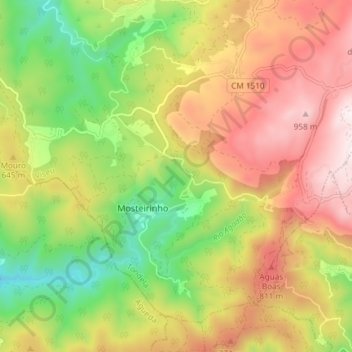
Name: Mosteirinho topographic map, elevation, terrain.
Location: Mosteirinho, Tondela, Viseu, 3475-060, Portugal (40.51383 -8.28911 40.56076 -8.21505)
Average elevation: 588 m
Minimum elevation: 204 m
Maximum elevation: 990 m
Other topographic maps
Click on a map to view its topography, its elevation and its terrain.
Barragem da Ribeira do Paul
Barragem da Ribeira do Paul, Vilar de Besteiros e Mosteiro de Fráguas, Tondela, Viseu, Portugal
Average elevation: 362 m
Barreiro de Besteiros
Barreiro de Besteiros, Tondela, Viseu, 3465-195, Portugal
Average elevation: 285 m