
Newcastle topographic map
Interactive map
Click on the map to display elevation.
About this map
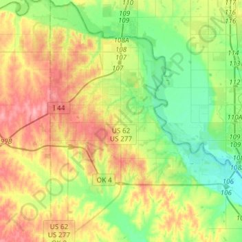
Name: Newcastle topographic map, elevation, terrain.
Location: Newcastle, McClain County, Oklahoma, 73065, United States (35.13514 -97.67098 35.33357 -97.48445)
Average elevation: 373 m
Minimum elevation: 332 m
Maximum elevation: 432 m
Other topographic maps
Click on a map to view its topography, its elevation and its terrain.
Byars
United States > Oklahoma > McClain County
Byars, McClain County, Oklahoma, United States
Average elevation: 315 m
Rosedale
United States > Oklahoma > McClain County
Rosedale, McClain County, Oklahoma, United States
Average elevation: 316 m
Goldsby
United States > Oklahoma > McClain County
Goldsby, McClain County, Oklahoma, United States
Average elevation: 350 m
Wayne
United States > Oklahoma > McClain County
Wayne, McClain County, Oklahoma, United States
Average elevation: 333 m
Purcell
United States > Oklahoma > McClain County
Purcell, McClain County, Oklahoma, United States
Average elevation: 333 m
Blanchard
United States > Oklahoma > McClain County
Blanchard, McClain County, Oklahoma, 73010, United States
Average elevation: 384 m