
Blanchard topographic map
Interactive map
Click on the map to display elevation.
About this map
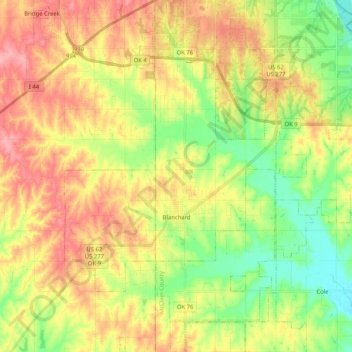
Name: Blanchard topographic map, elevation, terrain.
Location: Blanchard, McClain County, Oklahoma, 73010, United States (35.07317 -97.72368 35.24129 -97.59970)
Average elevation: 384 m
Minimum elevation: 336 m
Maximum elevation: 436 m
Other topographic maps
Click on a map to view its topography, its elevation and its terrain.
Byars
United States > Oklahoma > McClain County
Byars, McClain County, Oklahoma, United States
Average elevation: 315 m
Rosedale
United States > Oklahoma > McClain County
Rosedale, McClain County, Oklahoma, United States
Average elevation: 316 m
Goldsby
United States > Oklahoma > McClain County
Goldsby, McClain County, Oklahoma, United States
Average elevation: 350 m
Wayne
United States > Oklahoma > McClain County
Wayne, McClain County, Oklahoma, United States
Average elevation: 333 m
Purcell
United States > Oklahoma > McClain County
Purcell, McClain County, Oklahoma, United States
Average elevation: 333 m
Newcastle
United States > Oklahoma > McClain County
Newcastle, McClain County, Oklahoma, 73065, United States
Average elevation: 373 m