
Streeter topographic map
Interactive map
Click on the map to display elevation.
About this map
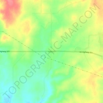
Name: Streeter topographic map, elevation, terrain.
Location: Streeter, Mason County, Texas, United States (30.74490 -99.39645 30.78490 -99.35645)
Average elevation: 521 m
Minimum elevation: 488 m
Maximum elevation: 559 m
Other topographic maps
Click on a map to view its topography, its elevation and its terrain.
Grit
United States > Texas > Mason County
Grit, Mason County, Texas, United States
Average elevation: 529 m
Fredonia
United States > Texas > Mason County
Fredonia, Mason County, Texas, 76842, United States
Average elevation: 509 m
Art
United States > Texas > Mason County
Art, Mason County, Texas, United States
Average elevation: 426 m
Pontotoc
United States > Texas > Mason County
Pontotoc, Mason County, Texas, 76869, United States
Average elevation: 470 m
Mason
United States > Texas > Mason County
Mason, Mason County, Texas, 76856, United States
Average elevation: 484 m