
North Pemba topographic map
Interactive map
Click on the map to display elevation.
About this map
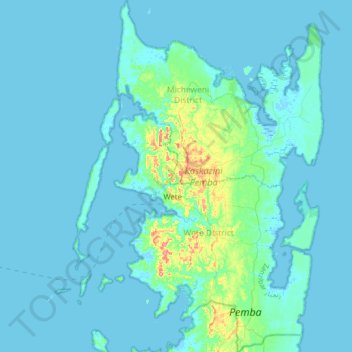
Name: North Pemba topographic map, elevation, terrain.
Location: North Pemba, Zanzibar, Tanzania (-5.20855 39.61276 -4.86436 39.87616)
Average elevation: 8 m
Minimum elevation: -4 m
Maximum elevation: 92 m
Other topographic maps
Click on a map to view its topography, its elevation and its terrain.
Kilimanjaro
Mount Kilimanjaro (/ˌkɪlɪmənˈdʒɑːroʊ/) is a dormant volcano in Tanzania. It is the highest mountain in Africa and the highest free-standing mountain above sea level in the world: 5,895 m (19,341 ft) above sea level and 4,900 m (16,100 ft) above its plateau base. It is also the highest volcano in the…
Average elevation: 1,537 m