
Shijiazhuang topographic map
Interactive map
Click on the map to display elevation.
Shijiazhuang
Shijiazhuang is situated east of the Taihang Mountains, a mountain range extending over 400 km (250 mi) from north to south with an average elevation of 1,500 to 2,000 m (4,900 to 6,600 ft), making Shijiazhuang a place for hiking, outdoor trips, and cycling.
About this map
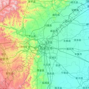
Name: Shijiazhuang topographic map, elevation, terrain.
Location: Shijiazhuang, Hebei, China (37.44111 113.51718 38.76263 115.47707)
Average elevation: 360 m
Minimum elevation: 19 m
Maximum elevation: 2,247 m
Other topographic maps
Click on a map to view its topography, its elevation and its terrain.