
Make a donation
Gothal topographic map
Click on the map to display elevation.
Make a donation
About this map
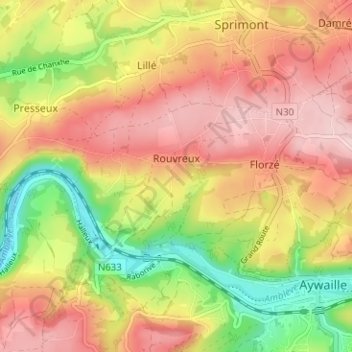
Name: Gothal topographic map, elevation, terrain.
Location: Gothal, Rouvreux, Sprimont, Liège, Wallonie, 4140, Belgique (50.46819 5.62992 50.50819 5.66992)
Average elevation: 217 m
Minimum elevation: 101 m
Maximum elevation: 308 m
Make a donation
Other topographic maps
Click on a map to view its topography, its elevation and its terrain.
Louveigné
Belgique > Liège > Liège > Sprimont
Le village de Louveigné se situe à une altitude de 260 mètres environ, sur la ligne de partage entre l'Amblève et la Vesdre, à la limite nord du vallon des chantoirs et de la région calcaire de la Calestienne ainsi qu'à la limite est du Condroz liégeois. Quant à l'Ardenne, elle occupe la partie…
Average elevation: 269 m
Make a donation
Dolembreux
Belgique > Liège > Liège > Sprimont
Dolembreux est un village de la province de Liège qui se situe dans le nord-ouest de la commune de Sprimont. Sa superficie est de 1080 ha. En plus du village principal, Dolembreux se compose de plusieurs hameaux, avec Betgné, Hautgné et Hayen qui se situent à l’ouest. La bordure nord du village, avec…
Average elevation: 237 m
Louveigné
Belgique > Liège > Liège > Sprimont
Le village de Louveigné se situe à une altitude de 260 mètres environ, sur la ligne de partage entre l'Amblève et la Vesdre, à la limite nord du vallon des chantoirs et de la région calcaire de la Calestienne ainsi qu'à la limite est du Condroz liégeois. Quant à l'Ardenne, elle occupe la partie…
Average elevation: 264 m