
兴发乡 topographic map
Interactive map
Click on the map to display elevation.
About this map
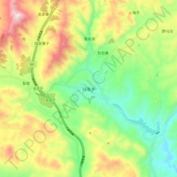
Name: 兴发乡 topographic map, elevation, terrain.
Location: 兴发乡, 赫章县, 毕节市, 贵州省, 中国 (26.90684 104.77616 26.98684 104.85616)
Average elevation: 2,141 m
Minimum elevation: 1,826 m
Maximum elevation: 2,601 m
Other topographic maps
Click on a map to view its topography, its elevation and its terrain.