
Lijiang City topographic map
Interactive map
Click on the map to display elevation.
About this map
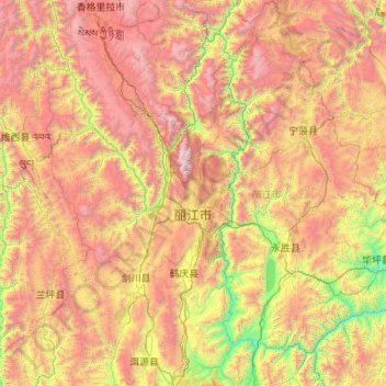
Name: Lijiang City topographic map, elevation, terrain.
Location: Lijiang City, Yunnan, China (25.98858 99.38218 27.92759 101.51230)
Average elevation: 2,735 m
Minimum elevation: 1,096 m
Maximum elevation: 5,476 m
Other topographic maps
Click on a map to view its topography, its elevation and its terrain.
Zhaotong
Influenced by the low latitude and moderate elevation, Zhaotong has a temperate subtropical highland climate (Köppen Cwb), with cool, dry winters, and warm, humid summers. Temperatures frequently drop below freezing at night in winter, though the days warm up to around 10 °C (50 °F). Conversely, in summer,…
Average elevation: 2,071 m