
Ighzer Amellal topographic map
Interactive map
Click on the map to display elevation.
About this map
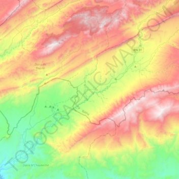
Name: Ighzer Amellal topographic map, elevation, terrain.
Location: Ighzer Amellal, Daïra de T'Kout, Batna, Algérie (34.88084 5.91548 35.21637 6.31529)
Average elevation: 970 m
Minimum elevation: 196 m
Maximum elevation: 1,925 m
Other topographic maps
Click on a map to view its topography, its elevation and its terrain.
T'Kout
Algérie > Batna > Daïra de T'Kout
T'Kout, Daïra de T'Kout, Batna, Algérie
Average elevation: 1,317 m
Ghassira
Algérie > Batna > Daïra de T'Kout
Ghassira, Daïra de T'Kout, Batna, Algérie
Average elevation: 1,162 m