
T'Kout topographic map
Interactive map
Click on the map to display elevation.
About this map
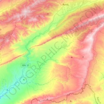
Name: T'Kout topographic map, elevation, terrain.
Location: T'Kout, Daïra de T'Kout, Batna, Algérie (35.05820 6.21927 35.24768 6.50210)
Average elevation: 1,317 m
Minimum elevation: 668 m
Maximum elevation: 2,000 m
La commune est située sur un plateau culminant à 1 200 m d'altitude, au-dessus de la vallée de l'oued Abiod (Ighzir Amellal en chaoui).
Other topographic maps
Click on a map to view its topography, its elevation and its terrain.
Ghassira
Algérie > Batna > Daïra de T'Kout
Ghassira, Daïra de T'Kout, Batna, Algérie
Average elevation: 1,162 m
Ighzer Amellal
Algérie > Batna > Daïra de T'Kout
Ighzer Amellal, Daïra de T'Kout, Batna, Algérie
Average elevation: 970 m