
Gladewater topographic map
Interactive map
Click on the map to display elevation.
About this map
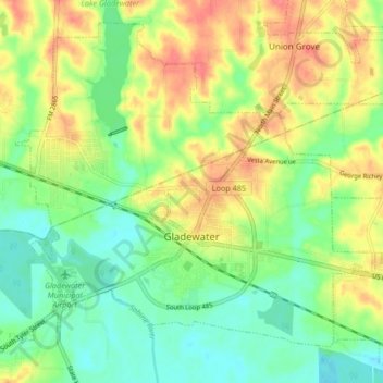
Name: Gladewater topographic map, elevation, terrain.
Location: Gladewater, Gregg County, Texas, 75647, United States (32.51385 -94.98633 32.57558 -94.90344)
Average elevation: 102 m
Minimum elevation: 76 m
Maximum elevation: 135 m
Other topographic maps
Click on a map to view its topography, its elevation and its terrain.
Longview
United States > Texas > Gregg County
Longview, Gregg County, Texas, United States
Average elevation: 105 m
White Oak
United States > Texas > Gregg County
White Oak, Gregg County, Texas, 75693, United States
Average elevation: 110 m
Liberty City
United States > Texas > Gregg County
Liberty City, Gregg County, Texas, United States
Average elevation: 116 m
Judson
United States > Texas > Gregg County > Judson
Judson, Gregg County, Texas, 75660, United States
Average elevation: 120 m
Gladewater
United States > Texas > Gregg County > Gladewater > Gladewater
Gladewater, Gregg County, Texas, 75647, United States
Average elevation: 99 m
Kilgore
United States > Texas > Gregg County > Kilgore
Kilgore, Gregg County, Texas, 75662, United States
Average elevation: 108 m
Kilgore
United States > Texas > Gregg County
Kilgore, Gregg County, Texas, United States
Average elevation: 108 m
Kilgore
United States > Texas > Gregg County
Kilgore, Gregg County, Texas, United States
Average elevation: 108 m