
Make a donation
Kimberley topographic map
Click on the map to display elevation.
Make a donation
About this map
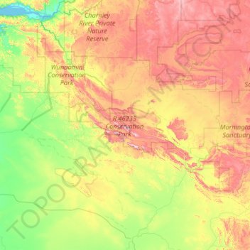
Name: Kimberley topographic map, elevation, terrain.
Average elevation: 274 m
Minimum elevation: 0 m
Maximum elevation: 913 m
Make a donation
Other topographic maps
Click on a map to view its topography, its elevation and its terrain.
Make a donation
Ellenbrook
The suburb sits in the south-east corner of the Gnangara Mound, close to the Darling Scarp. Topographically, the majority of Ellenbrook's area sits between 40-50 metres above sea level on the mound, with parts of Coolamon and Malvern Springs situated on hills that reach peaks of 65 metres. The northern village…
Average elevation: 49 m
Make a donation
Make a donation
Make a donation
Make a donation
Laverton
Laverton, originally known as British Flag, is a town in the Goldfields region of Western Australia, and the centre of administration for the Shire of Laverton. The town of Laverton is located at the western edge of the Great Victoria Desert, 957 kilometres (595 mi) north-northeast of the state capital, Perth,…
Average elevation: 447 m
Make a donation
Stirling Range National Park
The park is particularly rich in banksias, eucalypts, orchids and verticordias. Ten species of mountain bells (Darwinia spp.) have been identified in the park and only one of these is found outside Stirling Range. Five major vegetation communities are known in the park with thicket and mallee-heath at higher…
Average elevation: 235 m
Make a donation
Make a donation
Make a donation
Make a donation
Make a donation
Make a donation
Make a donation
Make a donation
Make a donation
Make a donation
Make a donation
Make a donation
Make a donation
Make a donation
Make a donation
Make a donation
Make a donation
Make a donation
Make a donation