
Thank you for supporting this site ❤️
Make a donation
Make a donation
Dalkeith topographic map
Click on the map to display elevation.
Thank you for supporting this site ❤️
Make a donation
Make a donation
About this map
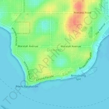
Name: Dalkeith topographic map, elevation, terrain.
Location: Dalkeith, City of Nedlands, Western Australia, Australia (-32.00491 115.78684 -31.98881 115.81343)
Average elevation: 14 m
Minimum elevation: 0 m
Maximum elevation: 46 m
Thank you for supporting this site ❤️
Make a donation
Make a donation
Other topographic maps
Click on a map to view its topography, its elevation and its terrain.