
Thank you for supporting this site ❤️
Make a donation
Make a donation
Schwingen topographic map
Click on the map to display elevation.
Thank you for supporting this site ❤️
Make a donation
Make a donation
Schwingen
Einzige Zufahrt ist eine Stichstraße, die in Höhe der Stadt Schwarzenbach nach Norden von der Bundesstraße 289 abzweigt. Im Westen des Ortes verläuft die Saale, im Osten die Lamitz. Der Jean-Paul-Weg führt durch den Ort.
Thank you for supporting this site ❤️
Make a donation
Make a donation
About this map
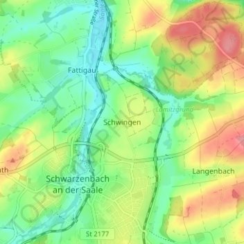
Name: Schwingen topographic map, elevation, terrain.
Average elevation: 523 m
Minimum elevation: 485 m
Maximum elevation: 581 m
Thank you for supporting this site ❤️
Make a donation
Make a donation
Other topographic maps
Click on a map to view its topography, its elevation and its terrain.
Förmitztalsperre
Deutschland > Bayern > Landkreis Hof > Schwarzenbach a.d.Saale > Völkenreuth
Average elevation: 542 m