
Thank you for supporting this site ❤️
Make a donation
Make a donation
Förbau topographic map
Click on the map to display elevation.
Thank you for supporting this site ❤️
Make a donation
Make a donation
About this map
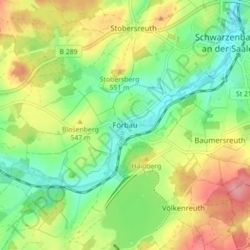
Name: Förbau topographic map, elevation, terrain.
Average elevation: 532 m
Minimum elevation: 492 m
Maximum elevation: 587 m
Thank you for supporting this site ❤️
Make a donation
Make a donation
Other topographic maps
Click on a map to view its topography, its elevation and its terrain.
Förmitztalsperre
Deutschland > Bayern > Landkreis Hof > Schwarzenbach a.d.Saale > Völkenreuth
Average elevation: 542 m