
Antlers topographic map
Interactive map
Click on the map to display elevation.
About this map
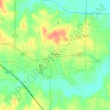
Name: Antlers topographic map, elevation, terrain.
Location: Antlers, Pushmataha County, Oklahoma, United States (34.21847 -95.65563 34.24556 -95.60097)
Average elevation: 154 m
Minimum elevation: 132 m
Maximum elevation: 182 m
Other topographic maps
Click on a map to view its topography, its elevation and its terrain.
Finley
United States > Oklahoma > Pushmataha County
Finley, Pushmataha County, Oklahoma, 74543, United States
Average elevation: 155 m
Nashoba
United States > Oklahoma > Pushmataha County
Nashoba, Pushmataha County, Oklahoma, 74558, United States
Average elevation: 233 m
Clayton
United States > Oklahoma > Pushmataha County
Clayton, Pushmataha County, Oklahoma, 74536, United States
Average elevation: 188 m
Albion
United States > Oklahoma > Pushmataha County > Albion
Albion, Pushmataha County, Oklahoma, 74524, United States
Average elevation: 207 m