
Finley topographic map
Interactive map
Click on the map to display elevation.
About this map
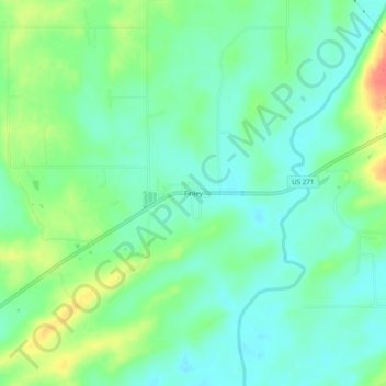
Name: Finley topographic map, elevation, terrain.
Location: Finley, Pushmataha County, Oklahoma, 74543, United States (34.30843 -95.51497 34.34843 -95.47497)
Average elevation: 155 m
Minimum elevation: 137 m
Maximum elevation: 191 m
Other topographic maps
Click on a map to view its topography, its elevation and its terrain.
Nashoba
United States > Oklahoma > Pushmataha County
Nashoba, Pushmataha County, Oklahoma, 74558, United States
Average elevation: 233 m
Clayton
United States > Oklahoma > Pushmataha County
Clayton, Pushmataha County, Oklahoma, 74536, United States
Average elevation: 188 m
Albion
United States > Oklahoma > Pushmataha County > Albion
Albion, Pushmataha County, Oklahoma, 74524, United States
Average elevation: 207 m
Antlers
United States > Oklahoma > Pushmataha County
Antlers, Pushmataha County, Oklahoma, United States
Average elevation: 154 m