
江阴镇 topographic map
Interactive map
Click on the map to display elevation.
About this map
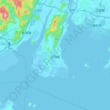
Name: 江阴镇 topographic map, elevation, terrain.
Location: 江阴镇, 福清市, 福州市, 福建省, 中国 (25.34410 119.25080 25.58007 119.45598)
Average elevation: 24 m
Minimum elevation: -7 m
Maximum elevation: 641 m
Other topographic maps
Click on a map to view its topography, its elevation and its terrain.