
Mississippi River topographic map
Interactive map
Click on the map to display elevation.
About this map
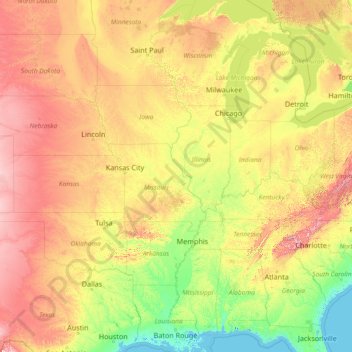
Name: Mississippi River topographic map, elevation, terrain.
Location: Mississippi River, United States (29.15784 -95.24694 47.49749 -89.09884)
Average elevation: 344 m
Minimum elevation: -3 m
Maximum elevation: 1,927 m
The uppermost lock and dam on the Upper Mississippi River is the Upper St. Anthony Falls Lock and Dam in Minneapolis. Above the dam, the river's elevation is 799 feet (244 m). Below the dam, the river's elevation is 750 feet (230 m). This 49-foot (15 m) drop is the largest of all the Mississippi River locks and dams. The origin of the dramatic drop is a waterfall preserved adjacent to the lock under an apron of concrete. Saint Anthony Falls is the only true waterfall on the entire Mississippi River. The water elevation continues to drop steeply as it passes through the gorge carved by the waterfall.
Other topographic maps
Click on a map to view its topography, its elevation and its terrain.
Houston
United States > Texas > Harris County
Houston, Harris County, Texas, United States
Average elevation: 25 m
Boulder
United States > Colorado > Boulder County
Boulder, Boulder County, Colorado, United States
Average elevation: 1,785 m
Montgomery County
Montgomery County, Texas, United States
Average elevation: 69 m
Los Angeles
Los Angeles, Los Angeles County, California, United States
Average elevation: 241 m
The Woodlands
United States > Texas > Montgomery County
The Woodlands, Montgomery County, Texas, United States
Average elevation: 47 m
Sequoia National Park
United States > California > Tulare County
Sequoia National Park, Tulare County, California, United States
Average elevation: 2,515 m
Spokane
United States > Washington > Spokane County
Spokane, Spokane County, Washington, United States
Average elevation: 655 m
Lancaster County
Lancaster County, Pennsylvania, United States
Average elevation: 158 m
Hudson River
Hudson River, New Jersey, 12834:12871, United States
Average elevation: 297 m
Fort Worth
United States > Texas > Tarrant County
Fort Worth, Tarrant County, Texas, United States
Average elevation: 212 m
Brooklyn
United States > New York > New York
Brooklyn, Kings County, New York, United States
Average elevation: 9 m
Tomball
United States > Texas > Harris County
Tomball, Harris County, Texas, 77375, United States
Average elevation: 52 m
New Orleans
United States > Louisiana > Orleans Parish
New Orleans, Orleans Parish, Louisiana, United States
Average elevation: 1 m
Queens County
United States > New York > New York
Queens County, New York, United States
Average elevation: 11 m
Norfolk
United States > Virginia > Norfolk
Norfolk, Virginia, 23510, United States
Average elevation: 4 m