
Nebraska topographic map
Interactive map
Click on the map to display elevation.
About this map
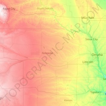
Name: Nebraska topographic map, elevation, terrain.
Location: Nebraska, United States (39.99998 -104.05352 43.00127 -95.30805)
Average elevation: 747 m
Minimum elevation: 255 m
Maximum elevation: 2,159 m
Nebraska is composed of two major land regions: the Dissected Till Plains and the Great Plains. The easternmost portion of the state was scoured by Ice Age glaciers; the Dissected Till Plains were left after the glaciers retreated. The Dissected Till Plains is a region of gently rolling hills; Omaha and Lincoln are in this region. The Great Plains occupy most of western Nebraska, with the region consisting of several smaller, diverse land regions, including the Sandhills, the Pine Ridge, the Rainwater Basin, the High Plains and the Wildcat Hills. Panorama Point, at 5,424 feet (1,653 m), is Nebraska's highest point; though despite its name and elevation, it is a relatively low rise near the Colorado and Wyoming borders. A past tourism slogan for the state of Nebraska was "Where the West Begins" (it has since been changed to "Honestly, it's not for everyone"). Locations given for the beginning of the "West" in Nebraska include the Missouri River, the intersection of 13th and O Streets in Lincoln (where it is marked by a red brick star), the 100th meridian, and Chimney Rock.
Other topographic maps
Click on a map to view its topography, its elevation and its terrain.
College Station
United States > Texas > Brazos County
College Station, Brazos County, Texas, United States
Average elevation: 87 m
Houston
United States > Texas > Harris County
Houston, Harris County, Texas, United States
Average elevation: 25 m
Sacramento
United States > California > Sacramento County
Sacramento, Sacramento County, California, United States
Average elevation: 10 m
Madison
United States > Wisconsin > Dane County
Madison, Dane County, Wisconsin, United States
Average elevation: 284 m
Spokane
United States > Washington > Spokane County
Spokane, Spokane County, Washington, United States
Average elevation: 655 m
New Orleans
United States > Louisiana > Orleans Parish
New Orleans, Orleans Parish, Louisiana, United States
Average elevation: 1 m
Staten Island
United States > New York > New York
Staten Island, Richmond County, New York, United States
Average elevation: 9 m
Central Park
United States > New York > New York County > New York
Central Park, New York County, New York, United States
Average elevation: 26 m
Boulder
United States > Colorado > Boulder County
Boulder, Boulder County, Colorado, United States
Average elevation: 1,785 m
Queens County
United States > New York > New York
Queens County, New York, United States
Average elevation: 11 m
Albuquerque
United States > New Mexico > Bernalillo County
Albuquerque, Bernalillo County, New Mexico, United States
Average elevation: 1,688 m
Norfolk
United States > Virginia > Norfolk
Norfolk, Virginia, 23510, United States
Average elevation: 4 m
Fort Lauderdale
United States > Florida > Broward County
Fort Lauderdale, Broward County, Florida, United States
Average elevation: 5 m
Ruidoso
United States > New Mexico > Lincoln County
Ruidoso, Lincoln County, New Mexico, United States
Average elevation: 2,287 m
Brooklyn
United States > New York > New York
Brooklyn, Kings County, New York, United States
Average elevation: 9 m