
Thank you for supporting this site ❤️
Make a donation
Make a donation
Walpertskirchen topographic map
Click on the map to display elevation.
Thank you for supporting this site ❤️
Make a donation
Make a donation
About this map
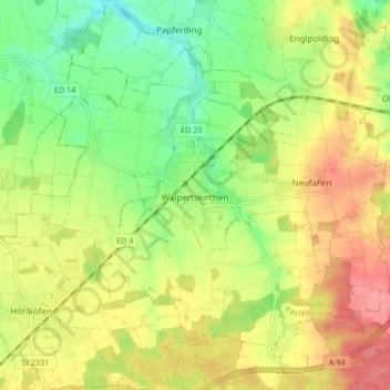
Name: Walpertskirchen topographic map, elevation, terrain.
Average elevation: 500 m
Minimum elevation: 462 m
Maximum elevation: 540 m
Thank you for supporting this site ❤️
Make a donation
Make a donation
Other topographic maps
Click on a map to view its topography, its elevation and its terrain.
Thank you for supporting this site ❤️
Make a donation
Make a donation
Thank you for supporting this site ❤️
Make a donation
Make a donation
Schnaupping
Deutschland > Bayern > Landkreis Erding > Taufkirchen > Angerskirchen > Schnaupping
Average elevation: 488 m
Thank you for supporting this site ❤️
Make a donation
Make a donation
Thank you for supporting this site ❤️
Make a donation
Make a donation
Thank you for supporting this site ❤️
Make a donation
Make a donation
Thank you for supporting this site ❤️
Make a donation
Make a donation
Thank you for supporting this site ❤️
Make a donation
Make a donation
Unterhausmehring
Deutschland > Bayern > Landkreis Erding > Dorfen > Kloster Moosen
Average elevation: 466 m
Thank you for supporting this site ❤️
Make a donation
Make a donation
Thank you for supporting this site ❤️
Make a donation
Make a donation
Thank you for supporting this site ❤️
Make a donation
Make a donation
Thank you for supporting this site ❤️
Make a donation
Make a donation
Pfaffing bei Watzling
Deutschland > Bayern > Landkreis Erding > Dorfen > Watzling
Average elevation: 481 m
Thank you for supporting this site ❤️
Make a donation
Make a donation
Thank you for supporting this site ❤️
Make a donation
Make a donation
Thank you for supporting this site ❤️
Make a donation
Make a donation