
Ovalle topographic map
Interactive map
Click on the map to display elevation.
About this map
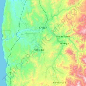
Name: Ovalle topographic map, elevation, terrain.
Location: Ovalle, Provincia de Limarí, Región de Coquimbo, Chile (-31.21650 -71.71563 -30.31047 -70.85255)
Average elevation: 765 m
Minimum elevation: 0 m
Maximum elevation: 3,718 m
Other topographic maps
Click on a map to view its topography, its elevation and its terrain.
Monte Patria
Chile > Región de Coquimbo > Provincia de Limarí
Monte Patria, Provincia de Limarí, Región de Coquimbo, 1880000, Chile
Average elevation: 1,387 m
Salala
Chile > Región de Coquimbo > Provincia de Limarí > Ovalle
Salala, Ovalle, Provincia de Limarí, Región de Coquimbo, Chile
Average elevation: 126 m
Maitencillo Sur
Chile > Región de Coquimbo > Provincia de Limarí > Ovalle
Maitencillo Sur, Ovalle, Provincia de Limarí, Región de Coquimbo, Chile
Average elevation: 234 m
Chalinga
Chile > Región de Coquimbo > Provincia de Limarí > Ovalle > Chalinga
Chalinga, Ovalle, Provincia de Limarí, Región de Coquimbo, Chile
Average elevation: 167 m