
Bear Mountain State Park topographic map
Interactive map
Click on the map to display elevation.
About this map
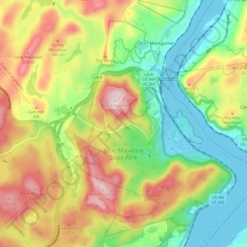
Name: Bear Mountain State Park topographic map, elevation, terrain.
Average elevation: 166 m
Minimum elevation: 0 m
Maximum elevation: 394 m
There are over 50 official trails covering 235 miles (378 km), featuring a wide range of difficulties and elevation changes.
Other topographic maps
Click on a map to view its topography, its elevation and its terrain.
Tomkins Cove
United States > New York > Rockland County > Town of Stony Point
Tomkins Cove, Town of Stony Point, Rockland County, New York, 10986, United States
Average elevation: 68 m
Buckberg
United States > New York > Rockland County > Town of Stony Point
Buckberg, Town of Stony Point, Rockland County, New York, 10986, United States
Average elevation: 108 m
Lake Welch
United States > New York > Rockland County > Town of Stony Point
Lake Welch, Town of Stony Point, Rockland County, New York, United States
Average elevation: 324 m