
Tomkins Cove topographic map
Interactive map
Click on the map to display elevation.
About this map
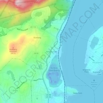
Name: Tomkins Cove topographic map, elevation, terrain.
Average elevation: 68 m
Minimum elevation: -43 m
Maximum elevation: 322 m
Other topographic maps
Click on a map to view its topography, its elevation and its terrain.
Buckberg
United States > New York > Rockland County > Town of Stony Point
Buckberg, Town of Stony Point, Rockland County, New York, 10986, United States
Average elevation: 108 m
Lake Welch
United States > New York > Rockland County > Town of Stony Point
Lake Welch, Town of Stony Point, Rockland County, New York, United States
Average elevation: 324 m
Bear Mountain State Park
United States > New York > Rockland County > Town of Stony Point
Bear Mountain State Park, Town of Stony Point, Town of Highlands, Rockland County, New York, United States
Average elevation: 166 m