
Springerville topographic map
Interactive map
Click on the map to display elevation.
About this map
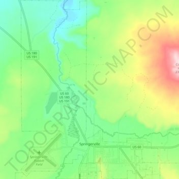
Name: Springerville topographic map, elevation, terrain.
Location: Springerville, Apache County, Arizona, United States (34.11833 -109.32331 34.19819 -109.24908)
Average elevation: 2,150 m
Minimum elevation: 2,041 m
Maximum elevation: 2,356 m
Springerville sits at an elevation of 6,974 feet (2,126 m) above sea level. Along with its neighbor Eagar, the communities make up the place known as Round Valley, which is in the central-eastern part of Arizona close to the New Mexico border.
Other topographic maps
Click on a map to view its topography, its elevation and its terrain.
Concho
United States > Arizona > Apache County
Concho, Apache County, Arizona, 85914, United States
Average elevation: 1,844 m
Fort Defiance
United States > Arizona > Apache County
Fort Defiance, Fort Defiance Agency, Apache County, Arizona, 86504, United States
Average elevation: 2,142 m
Nutrioso
United States > Arizona > Apache County
Nutrioso, Apache County, Arizona, 85932, United States
Average elevation: 2,404 m
Alpine
United States > Arizona > Apache County
Alpine, Apache County, Arizona, 75920, United States
Average elevation: 2,611 m
McNary
United States > Arizona > Apache County
McNary, Apache County, Arizona, 85930, United States
Average elevation: 2,228 m
Ganado
United States > Arizona > Apache County
Ganado, Fort Defiance Agency, Apache County, Arizona, United States
Average elevation: 1,991 m
Dennehotso
United States > Arizona > Apache County
Dennehotso, Apache County, Arizona, 86535, United States
Average elevation: 1,539 m
Round Rock
United States > Arizona > Apache County
Round Rock, Chinle Agency, Apache County, Arizona, 86547, United States
Average elevation: 1,664 m
Burnside
United States > Arizona > Apache County
Burnside, Fort Defiance Agency, Apache County, Arizona, United States
Average elevation: 1,956 m
Tsaile
United States > Arizona > Apache County
Tsaile, Chinle Agency, Apache County, Arizona, United States
Average elevation: 2,158 m
Houck
United States > Arizona > Apache County
Houck, Fort Defiance Agency, Apache County, Arizona, United States
Average elevation: 1,890 m
Lukachukai
United States > Arizona > Apache County
Lukachukai, Chinle Agency, Apache County, Arizona, 86507, United States
Average elevation: 2,004 m
Many Farms
United States > Arizona > Apache County
Many Farms, Chinle Agency, Apache County, Arizona, 86538, United States
Average elevation: 1,625 m
Rock Point
United States > Arizona > Apache County
Rock Point, Shiprock Agency, Apache County, Arizona, United States
Average elevation: 1,536 m
Sanders
United States > Arizona > Apache County
Sanders, Apache County, Arizona, 86512, United States
Average elevation: 1,801 m
Blue Gap
United States > Arizona > Apache County
Blue Gap, Chinle Agency, Apache County, Arizona, 86520, United States
Average elevation: 1,989 m
Cottonwood
United States > Arizona > Apache County
Cottonwood, Chinle Agency, Apache County, Arizona, United States
Average elevation: 1,873 m
Cornfields
United States > Arizona > Apache County
Cornfields, Fort Defiance Agency, Apache County, Arizona, United States
Average elevation: 1,880 m
Del Muerto
United States > Arizona > Apache County
Del Muerto, Chinle Agency, Apache County, Arizona, United States
Average elevation: 1,956 m
Teec Nos Pos
United States > Arizona > Apache County
Teec Nos Pos, Shiprock Agency, Apache County, Arizona, United States
Average elevation: 1,620 m
Chinle Agency
United States > Arizona > Apache County
Chinle Agency, Apache County, Arizona, United States
Average elevation: 1,966 m
Vernon
United States > Arizona > Apache County
Vernon, Apache County, Arizona, 89540, United States
Average elevation: 2,119 m
Eagar
United States > Arizona > Apache County
Eagar, Apache County, Arizona, 85925, United States
Average elevation: 2,227 m
Window Rock
United States > Arizona > Apache County
Window Rock, Fort Defiance Agency, Apache County, Arizona, United States
Average elevation: 2,084 m
Upper Forest Mountain
United States > Arizona > Apache County
Upper Forest Mountain, Chinle Agency, Apache County, Arizona, United States
Average elevation: 2,279 m
Coyote Springs
United States > Arizona > Apache County
Coyote Springs, Chinle Agency, Apache County, Arizona, United States
Average elevation: 1,743 m
Chambers
United States > Arizona > Apache County
Chambers, Apache County, Arizona, United States
Average elevation: 1,776 m
Fort Defiance Agency
United States > Arizona > Apache County
Fort Defiance Agency, Apache County, Arizona, United States
Average elevation: 1,913 m
Window Rock
United States > Arizona > Apache County
Window Rock, Apache County, Arizona, United States
Average elevation: 2,084 m
Lupton
United States > Arizona > Apache County
Lupton, Fort Defiance Agency, Apache County, Arizona, 86508, United States
Average elevation: 1,942 m
Cerro Hueco
United States > Arizona > Apache County
Cerro Hueco, Apache County, Arizona, United States
Average elevation: 2,105 m
Hawley Lake
United States > Arizona > Apache County > Hawley Lake
Hawley Lake, Apache County, Arizona, United States
Average elevation: 2,538 m
St. Johns
United States > Arizona > Apache County > St. Johns > St. Johns
St. Johns, Apache County, Arizona, 85936, United States
Average elevation: 1,755 m
White Hills
United States > Arizona > Apache County
White Hills, Chinle Agency, Apache County, Arizona, United States
Average elevation: 1,801 m
Greer
United States > Arizona > Apache County
Greer, Apache County, Arizona, 85927, United States
Average elevation: 2,669 m
White Butte
United States > Arizona > Apache County
White Butte, Chinle Agency, Apache County, Arizona, United States
Average elevation: 2,210 m
Saint Michaels
United States > Arizona > Apache County
Saint Michaels, Fort Defiance Agency, Apache County, Arizona, 86511, United States
Average elevation: 2,059 m
Petrified Forest National Park
United States > Arizona > Apache County
Petrified Forest National Park, Apache County, Arizona, 86028, United States
Average elevation: 1,722 m
St. Johns
United States > Arizona > Apache County
St. Johns, Apache County, Arizona, 85936, United States
Average elevation: 1,757 m
Steamboat
United States > Arizona > Apache County
Steamboat, Fort Defiance Agency, Apache County, Arizona, United States
Average elevation: 1,969 m
Chinle
United States > Arizona > Apache County
Chinle, Chinle Agency, Apache County, Arizona, United States
Average elevation: 1,715 m
Red Rock
United States > Arizona > Apache County
Red Rock, Shiprock Agency, Apache County, Arizona, United States
Average elevation: 1,780 m