
Thank you for supporting this site ❤️
Make a donation
Make a donation
Ripley County topographic map
Click on the map to display elevation.
Thank you for supporting this site ❤️
Make a donation
Make a donation
About this map
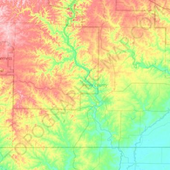
Name: Ripley County topographic map, elevation, terrain.
Location: Ripley County, Missouri, United States (36.49770 -91.12663 36.82420 -90.57443)
Average elevation: 166 m
Minimum elevation: 85 m
Maximum elevation: 298 m
Thank you for supporting this site ❤️
Make a donation
Make a donation
Other topographic maps
Click on a map to view its topography, its elevation and its terrain.