
黄山国家风景名胜区 topographic map
Interactive map
Click on the map to display elevation.
About this map
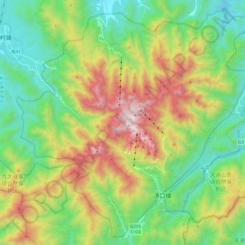
Name: 黄山国家风景名胜区 topographic map, elevation, terrain.
Location: 黄山国家风景名胜区, 黄山风景区, 黄山区, 黄山市, 安徽省, 中国 (30.05666 118.07653 30.20685 118.26137)
Average elevation: 754 m
Minimum elevation: 196 m
Maximum elevation: 1,809 m
黄山位于中国安徽省南部黄山市境内,南北长约40公里,东西宽约30公里,山脉面积1200平方公里,核心景区面积约160.6平方公里,主体以花岗岩构成,最高处莲花峰,海拔1864.8米。
Other topographic maps
Click on a map to view its topography, its elevation and its terrain.