Geolocate

迎客松 topographic map

Interactive map

Click on the map to display elevation.

About this map

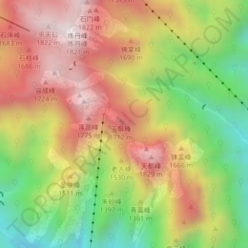
Name: 迎客松 topographic map, elevation, terrain.

Location: 迎客松, 黄山风景区, 黄山区, 黄山市, 安徽省, 中国 (30.11459 118.16035 30.13459 118.18035)

Average elevation: 1,366 m

Minimum elevation: 883 m

Maximum elevation: 1,810 m

Other topographic maps

Click on a map to view its topography, its elevation and its terrain.

黄山国家风景名胜区

中国 > 安徽省 > 黄山区

黄山国家风景名胜区, 黄山风景区, 黄山区, 黄山市, 安徽省, 中国

Average elevation: 754 m

汤口镇

中国 > 安徽省 > 黄山区

汤口镇, 黄山区, 黄山市, 安徽省, 中国

Average elevation: 679 m

太平湖镇

中国 > 安徽省 > 黄山区

太平湖镇, 黄山区, 黄山市, 安徽省, 中国

Average elevation: 234 m

甘棠镇

中国 > 安徽省 > 黄山区

甘棠镇, 黄山区, 黄山市, 安徽省, 242700, 中国

Average elevation: 301 m

谭家桥镇

中国 > 安徽省 > 黄山区

谭家桥镇, 黄山区, 黄山市, 安徽省, 中国

Average elevation: 544 m

黄山风景区

中国 > 安徽省 > 黄山区

黄山风景区, 黄山区, 黄山市, 安徽省, 中国

Average elevation: 942 m