
Lost Creek Lake topographic map
Interactive map
Click on the map to display elevation.
About this map
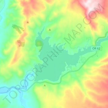
Name: Lost Creek Lake topographic map, elevation, terrain.
Location: Lost Creek Lake, Jackson County, Oregon, United States (42.66482 -122.67607 42.71425 -122.54510)
Average elevation: 729 m
Minimum elevation: 458 m
Maximum elevation: 1,282 m
The primary purpose of the dam is flood control and is operated in conjunction with Applegate Dam to regulate water flows down the river as well as to impound water for summer use. The dam is an earthfill structure with a gated spillway and contains two hydroelectric generating units with a total capacity of 49 megawatts. The hydroelectric plant has a rated flow capacity of 2,600 cubic feet per second (74 m3/s). The technologically advanced and unusual intake tower regulates water temperature by combining lake water from different depths in a mixing chamber before releasing it downstream. This serves to cool the normally warm summer water of the Rogue River, which improves conditions for fish migration and survival. The dam is 3,750 feet (1,140 m) long, 327 feet (100 m) high, with the top of the dam at an elevation of 1,882 feet (574 m) above mean sea level (MSL).The river below the dam is a popular area for easy rafting and tubing in the summer when the water is relatively warm. Joseph H. Stewart State Recreation Area is located along the southern shore of the lake. Casey State Park is located on the Rogue River below the dam.
Other topographic maps
Click on a map to view its topography, its elevation and its terrain.
Ashland
United States > Oregon > Jackson County
Ashland, Jackson County, Oregon, United States
Average elevation: 774 m
Trail
United States > Oregon > Jackson County
Trail, Jackson County, Oregon, 97539, United States
Average elevation: 534 m
Ruch
United States > Oregon > Jackson County
Ruch, Jackson County, Oregon, United States
Average elevation: 560 m
Applegate
United States > Oregon > Jackson County
Applegate, Jackson County, Oregon, United States
Average elevation: 501 m
Medford
United States > Oregon > Jackson County
Medford, Jackson County, Oregon, United States
Average elevation: 441 m
White City
United States > Oregon > Jackson County
White City, Jackson County, Oregon, 97503, United States
Average elevation: 404 m
Siskiyou Gap
United States > Oregon > Jackson County
Siskiyou Gap, Jackson County, Oregon, United States
Average elevation: 1,746 m
Fish Lake
United States > Oregon > Jackson County
Fish Lake, Jackson County, Oregon, United States
Average elevation: 1,456 m
Shady Cove
United States > Oregon > Jackson County
Shady Cove, Jackson County, Oregon, 97539, United States
Average elevation: 506 m
Eagle Point
United States > Oregon > Jackson County
Eagle Point, Jackson County, Oregon, 97524, United States
Average elevation: 422 m
Central Point
United States > Oregon > Jackson County
Central Point, Jackson County, Oregon, 97502, United States
Average elevation: 385 m
Buncom
United States > Oregon > Jackson County
Buncom, Jackson County, Oregon, United States
Average elevation: 654 m
Mount Ashland
United States > Oregon > Jackson County
Mount Ashland, Jackson County, Oregon, United States
Average elevation: 1,957 m
Rogue River
United States > Oregon > Jackson County
Rogue River, Jackson County, Oregon, 97537, United States
Average elevation: 362 m
Phoenix
United States > Oregon > Jackson County
Phoenix, Jackson County, Oregon, 97535, United States
Average elevation: 469 m
Wagner Butte
United States > Oregon > Jackson County
Wagner Butte, Jackson County, Oregon, United States
Average elevation: 1,848 m
Gold Hill
United States > Oregon > Jackson County
Gold Hill, Jackson County, Oregon, United States
Average elevation: 416 m
Talent
United States > Oregon > Jackson County
Talent, Jackson County, Oregon, United States
Average elevation: 516 m
Jacksonville
United States > Oregon > Jackson County
Jacksonville, Jackson County, Oregon, 97530, United States
Average elevation: 522 m