
Siskiyou Gap topographic map
Interactive map
Click on the map to display elevation.
About this map
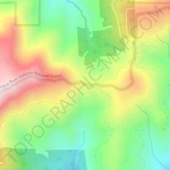
Name: Siskiyou Gap topographic map, elevation, terrain.
Location: Siskiyou Gap, Jackson County, Oregon, United States (42.05046 -122.80636 42.05056 -122.80626)
Average elevation: 1,746 m
Minimum elevation: 1,485 m
Maximum elevation: 2,076 m
"The original pass crosses the divide between the Rogue and Klamath Rivers at a slight topographic notch formed by the geological contact between the older Siskiyou Mountains to the west and the younger volcanic Cascade Range to the east." (Jeffrey M. LaLande, retired, forest archaeologist, Rogue River-Siskiyou National Forest)
Other topographic maps
Click on a map to view its topography, its elevation and its terrain.
Ashland
United States > Oregon > Jackson County
Ashland, Jackson County, Oregon, United States
Average elevation: 774 m
Trail
United States > Oregon > Jackson County
Trail, Jackson County, Oregon, 97539, United States
Average elevation: 534 m
Ruch
United States > Oregon > Jackson County
Ruch, Jackson County, Oregon, United States
Average elevation: 560 m
Applegate
United States > Oregon > Jackson County
Applegate, Jackson County, Oregon, United States
Average elevation: 501 m
Medford
United States > Oregon > Jackson County
Medford, Jackson County, Oregon, United States
Average elevation: 441 m
White City
United States > Oregon > Jackson County
White City, Jackson County, Oregon, 97503, United States
Average elevation: 404 m
Fish Lake
United States > Oregon > Jackson County
Fish Lake, Jackson County, Oregon, United States
Average elevation: 1,456 m
Shady Cove
United States > Oregon > Jackson County
Shady Cove, Jackson County, Oregon, 97539, United States
Average elevation: 506 m
Eagle Point
United States > Oregon > Jackson County
Eagle Point, Jackson County, Oregon, 97524, United States
Average elevation: 422 m
Central Point
United States > Oregon > Jackson County
Central Point, Jackson County, Oregon, 97502, United States
Average elevation: 385 m
Lost Creek Lake
United States > Oregon > Jackson County
Lost Creek Lake, Jackson County, Oregon, United States
Average elevation: 729 m
Buncom
United States > Oregon > Jackson County
Buncom, Jackson County, Oregon, United States
Average elevation: 654 m
Mount Ashland
United States > Oregon > Jackson County
Mount Ashland, Jackson County, Oregon, United States
Average elevation: 1,957 m
Rogue River
United States > Oregon > Jackson County
Rogue River, Jackson County, Oregon, 97537, United States
Average elevation: 362 m
Phoenix
United States > Oregon > Jackson County
Phoenix, Jackson County, Oregon, 97535, United States
Average elevation: 469 m
Wagner Butte
United States > Oregon > Jackson County
Wagner Butte, Jackson County, Oregon, United States
Average elevation: 1,848 m
Gold Hill
United States > Oregon > Jackson County
Gold Hill, Jackson County, Oregon, United States
Average elevation: 416 m
Talent
United States > Oregon > Jackson County
Talent, Jackson County, Oregon, United States
Average elevation: 516 m
Jacksonville
United States > Oregon > Jackson County
Jacksonville, Jackson County, Oregon, 97530, United States
Average elevation: 522 m