
Lichtenfels topographic map
Interactive map
Click on the map to display elevation.
About this map
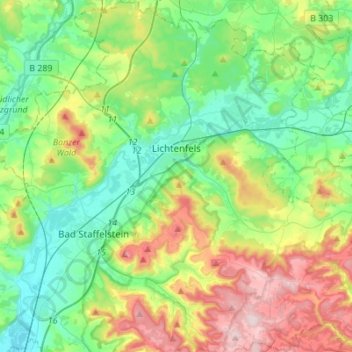
Name: Lichtenfels topographic map, elevation, terrain.
Location: Lichtenfels, Landkreis Lichtenfels, Bayern, 96215, Deutschland (50.04347 10.97516 50.21959 11.18991)
Average elevation: 348 m
Minimum elevation: 243 m
Maximum elevation: 575 m
Bohnberg | Buch am Forst | Burgberg | Degendorf | Eichig | Friesenhof | Gnellenroth | Hammer | Heinach | Isling | Karolinenhöhe | Klosterlangheim | Kösten | Köttel | Krappenroth | Lahm | Mistelfeld | Mönchkröttendorf | Nassanger | Oberlangheim | Oberwallenstadt | Reundorf | Roth | Rothmannsthal | Schney | Schönsreuth | Seehof | Seubelsdorf | Stetten | Stöcken | Tiefenroth | Trieb | Unterwallenstadt | Weingarten
Other topographic maps
Click on a map to view its topography, its elevation and its terrain.
Schwabthal
Deutschland > Bayern > Landkreis Lichtenfels > Bad Staffelstein
Schwabthal, Bad Staffelstein, Landkreis Lichtenfels, Bayern, Deutschland
Average elevation: 432 m
Döringstadt
Deutschland > Bayern > Landkreis Lichtenfels
Döringstadt, Ebensfeld, Landkreis Lichtenfels, Bayern, 96250, Deutschland
Average elevation: 299 m
Schwürbitz
Deutschland > Bayern > Landkreis Lichtenfels
Schwürbitz, Michelau i.OFr., Landkreis Lichtenfels, Bayern, 96275, Deutschland
Average elevation: 292 m