
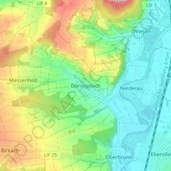
Döringstadt topographic map
Interactive map
Click on the map to display elevation.
About this map
Name: Döringstadt topographic map, elevation, terrain.
Average elevation: 299 m
Minimum elevation: 244 m
Maximum elevation: 400 m
Other topographic maps
Click on a map to view its topography, its elevation and its terrain.
Schwabthal
Deutschland > Bayern > Landkreis Lichtenfels > Bad Staffelstein
Schwabthal, Bad Staffelstein, Landkreis Lichtenfels, Bayern, Deutschland
Average elevation: 432 m
Schwürbitz
Deutschland > Bayern > Landkreis Lichtenfels
Schwürbitz, Michelau i.OFr., Landkreis Lichtenfels, Bayern, 96275, Deutschland
Average elevation: 292 m
Lichtenfels
Deutschland > Bayern > Landkreis Lichtenfels
Lichtenfels, Landkreis Lichtenfels, Bayern, 96215, Deutschland
Average elevation: 348 m