
Delecke topographic map
Interactive map
Click on the map to display elevation.
About this map
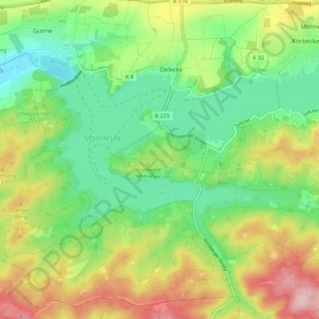
Name: Delecke topographic map, elevation, terrain.
Location: Delecke, Möhnesee, Kreis Soest, Nordrhein-Westfalen, Deutschland (51.44432 8.04393 51.50498 8.12078)
Average elevation: 255 m
Minimum elevation: 176 m
Maximum elevation: 378 m
Other topographic maps
Click on a map to view its topography, its elevation and its terrain.
Stockum
Deutschland > Nordrhein-Westfalen > Kreis Soest > Möhnesee
Stockum, Möhnesee, Kreis Soest, Nordrhein-Westfalen, Deutschland
Average elevation: 272 m
Völlinghausen
Deutschland > Nordrhein-Westfalen > Kreis Soest > Möhnesee
Völlinghausen, Möhnesee, Kreis Soest, Nordrhein-Westfalen, Deutschland
Average elevation: 296 m
Südufer
Deutschland > Nordrhein-Westfalen > Kreis Soest > Möhnesee
Südufer, Körbecke, Möhnesee, Kreis Soest, Nordrhein-Westfalen, 59519, Deutschland
Average elevation: 253 m