
Südufer topographic map
Interactive map
Click on the map to display elevation.
About this map
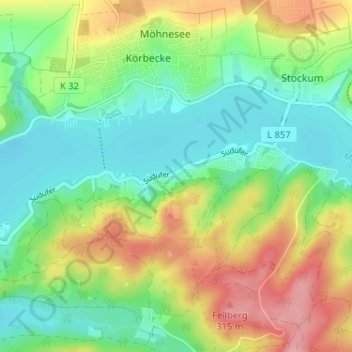
Name: Südufer topographic map, elevation, terrain.
Average elevation: 253 m
Minimum elevation: 208 m
Maximum elevation: 327 m
Other topographic maps
Click on a map to view its topography, its elevation and its terrain.
Stockum
Deutschland > Nordrhein-Westfalen > Kreis Soest > Möhnesee
Stockum, Möhnesee, Kreis Soest, Nordrhein-Westfalen, Deutschland
Average elevation: 272 m
Völlinghausen
Deutschland > Nordrhein-Westfalen > Kreis Soest > Möhnesee
Völlinghausen, Möhnesee, Kreis Soest, Nordrhein-Westfalen, Deutschland
Average elevation: 296 m
Delecke
Deutschland > Nordrhein-Westfalen > Kreis Soest > Möhnesee
Delecke, Möhnesee, Kreis Soest, Nordrhein-Westfalen, Deutschland
Average elevation: 255 m