
Daşoguz topographic map
Interactive map
Click on the map to display elevation.
About this map
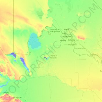
Name: Daşoguz topographic map, elevation, terrain.
Location: Daşoguz, Turkmenistan (38.78621 55.95860 43.98621 61.15860)
Average elevation: 114 m
Minimum elevation: -36 m
Maximum elevation: 967 m
Other topographic maps
Click on a map to view its topography, its elevation and its terrain.
Sarahs
Turkmenistan > Ahal Region > Sarahs District
Sarahs (Turkmen pronunciation: [θɑˈrɑχθ], also written Saraghs, Serahs, Sarakhs, Saragt, or Serakhs, the last a backformation of Russian: Серахс) is an oasis city in Ahal Province, Turkmenistan, and the administrative center of Sarahs district (Turkmen: Sarahs etraby). It is located at latitude…
Average elevation: 279 m
Turkmenabat
Türkmenabat is located at an altitude of 187 m (614 ft) on the banks of the Amu Darya River, near the border with Uzbekistan. Türkmenabat is at the center of Lebap province, which has borders with three provinces in Turkmenistan: Mary, Ahal and Daşoguz. The province also borders Uzbekistan and Afghanistan.
Average elevation: 194 m