
Dashoguz Region topographic map
Interactive map
Click on the map to display elevation.
About this map
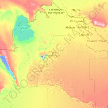
Name: Dashoguz Region topographic map, elevation, terrain.
Location: Dashoguz Region, Turkmenistan (39.46727 56.42917 42.79967 60.94490)
Average elevation: 98 m
Minimum elevation: -72 m
Maximum elevation: 410 m
Other topographic maps
Click on a map to view its topography, its elevation and its terrain.
Sarahs
Turkmenistan > Ahal Region > Sarahs District
Sarahs (Turkmen pronunciation: [θɑˈrɑχθ], also written Saraghs, Serahs, Sarakhs, Saragt, or Serakhs, the last a backformation of Russian: Серахс) is an oasis city in Ahal Province, Turkmenistan, and the administrative center of Sarahs district (Turkmen: Sarahs etraby). It is located at latitude…
Average elevation: 279 m