
Volterra topographic map
Interactive map
Click on the map to display elevation.
About this map
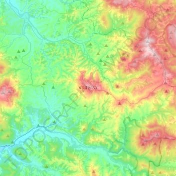
Name: Volterra topographic map, elevation, terrain.
Location: Volterra, Pisa, Tuscany, 56048, Italy (43.30215 10.76978 43.49742 11.01401)
Average elevation: 228 m
Minimum elevation: 44 m
Maximum elevation: 626 m
Other topographic maps
Click on a map to view its topography, its elevation and its terrain.
Castelfranco di Sotto
Castelfranco di Sotto, Pisa, Tuscany, Italy
Average elevation: 34 m
Montebicchieri
Italy > Tuscany > Pisa > San Miniato
Montebicchieri, San Miniato, Pisa, Tuscany, 56024, Italy
Average elevation: 79 m
Monteverdi Marittimo
Italy > Tuscany > Pisa > Monteverdi Marittimo
Monteverdi Marittimo, Pisa, Tuscany, Italy
Average elevation: 253 m