
Thank you for supporting this site ❤️
Make a donation
Make a donation
Buti topographic map
Click on the map to display elevation.
Thank you for supporting this site ❤️
Make a donation
Make a donation
About this map
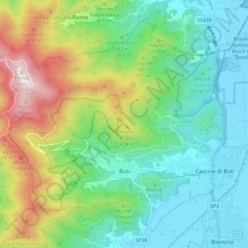
Name: Buti topographic map, elevation, terrain.
Location: Buti, Pisa, Tuscany, 56032, Italy (43.71303 10.54684 43.76406 10.62958)
Average elevation: 280 m
Minimum elevation: 2 m
Maximum elevation: 919 m
Thank you for supporting this site ❤️
Make a donation
Make a donation
Other topographic maps
Click on a map to view its topography, its elevation and its terrain.