
Gun Lake topographic map
Interactive map
Click on the map to display elevation.
About this map
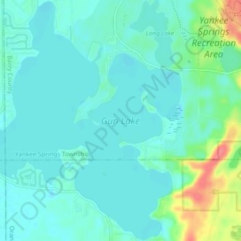
Name: Gun Lake topographic map, elevation, terrain.
Average elevation: 234 m
Minimum elevation: 222 m
Maximum elevation: 285 m
Other topographic maps
Click on a map to view its topography, its elevation and its terrain.
Hastings Township
United States > Michigan > Barry County
Hastings Township, Barry County, Michigan, United States
Average elevation: 265 m
Hastings
United States > Michigan > Barry County
Hastings, Barry County, Michigan, 49058, United States
Average elevation: 252 m
Thornapple River
United States > Michigan > Barry County > Irving
Thornapple River, Irving, Irving Township, Barry County, Michigan, United States
Average elevation: 236 m