
Thank you for supporting this site ❤️
Make a donation
Make a donation
Point of Rocks topographic map
Click on the map to display elevation.
Thank you for supporting this site ❤️
Make a donation
Make a donation
About this map
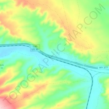
Name: Point of Rocks topographic map, elevation, terrain.
Location: Point of Rocks, Sweetwater County, Wyoming, United States (41.67223 -108.80764 41.69396 -108.73154)
Average elevation: 2,060 m
Minimum elevation: 1,974 m
Maximum elevation: 2,212 m
Thank you for supporting this site ❤️
Make a donation
Make a donation
Other topographic maps
Click on a map to view its topography, its elevation and its terrain.