
Wintersdorf topographic map
Interactive map
Click on the map to display elevation.
About this map
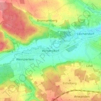
Name: Wintersdorf topographic map, elevation, terrain.
Average elevation: 336 m
Minimum elevation: 296 m
Maximum elevation: 384 m
Other topographic maps
Click on a map to view its topography, its elevation and its terrain.
Anwanden
Deutschland > Bayern > Landkreis Fürth > Zirndorf
Anwanden, Zirndorf, Landkreis Fürth, Bayern, 90522, Deutschland
Average elevation: 353 m
Weinzierlein
Deutschland > Bayern > Landkreis Fürth > Zirndorf
Weinzierlein, Zirndorf, Landkreis Fürth, Bayern, 90574, Deutschland
Average elevation: 342 m
Lind
Deutschland > Bayern > Landkreis Fürth > Zirndorf
Lind, Zirndorf, Landkreis Fürth, Bayern, 90513, Deutschland
Average elevation: 334 m
Bronnamberg
Deutschland > Bayern > Landkreis Fürth > Zirndorf
Bronnamberg, Zirndorf, Landkreis Fürth, Bayern, 90513, Deutschland
Average elevation: 338 m