
Semawung topographic map
Interactive map
Click on the map to display elevation.
About this map
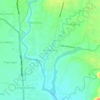
Name: Semawung topographic map, elevation, terrain.
Location: Semawung, Purworejo, Central Java, 54119, Indonesia (-7.77220 109.99526 -7.73220 110.03526)
Average elevation: 39 m
Minimum elevation: 18 m
Maximum elevation: 96 m
Other topographic maps
Click on a map to view its topography, its elevation and its terrain.
Grabag
Indonesia > Central Java > Purworejo > Grabag
Grabag, Purworejo, Central Java, Indonesia
Average elevation: 9 m
Dudukulon
Indonesia > Central Java > Purworejo > Dudukulon
Dudukulon, Purworejo, Central Java, Indonesia
Average elevation: 6 m