
Upper Lake topographic map
Interactive map
Click on the map to display elevation.
About this map
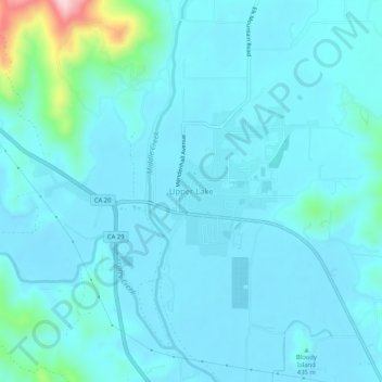
Name: Upper Lake topographic map, elevation, terrain.
Location: Upper Lake, Lake County, California, 95485, United States (39.14461 -122.93055 39.18461 -122.89055)
Average elevation: 429 m
Minimum elevation: 400 m
Maximum elevation: 663 m
Upper Lake is a census-designated place (CDP) in Lake County, California, United States. Upper Lake is located 8 miles (13 km) north of Lakeport, at an elevation of 1,345 feet (410 m). The population was 1,052 at the 2010 census, up from 989 at the 2000 census. The Habematolel Pomo of Upper Lake are headquartered here.
Other topographic maps
Click on a map to view its topography, its elevation and its terrain.
Clearlake Oaks
United States > California > Lake County
Clearlake Oaks, Lake County, California, 95423, United States
Average elevation: 521 m
Soda Bay
United States > California > Lake County
Soda Bay, Lake County, California, 95451, United States
Average elevation: 566 m
North Lakeport
United States > California > Lake County
North Lakeport, Lake County, California, United States
Average elevation: 427 m
Nice
United States > California > Lake County
Nice, Lake County, California, United States
Average elevation: 561 m
Lucerne
United States > California > Lake County
Lucerne, Lake County, California, 95458, United States
Average elevation: 519 m
Mount Konocti
United States > California > Lake County
Mount Konocti, Lake County, California, 95451, United States
Average elevation: 946 m
Lakeport
United States > California > Lake County
Lakeport, Lake County, California, United States
Average elevation: 417 m
Honeymoon Cove
United States > California > Lake County
Honeymoon Cove, Lake County, California, 95443, United States
Average elevation: 408 m
Spring Valley
United States > California > Lake County
Spring Valley, Lake County, California, United States
Average elevation: 488 m
Lower Lake
United States > California > Lake County
Lower Lake, Lake County, California, 95457, United States
Average elevation: 490 m
Middletown
United States > California > Lake County > Middletown
Middletown, Lake County, California, United States
Average elevation: 377 m
Hobergs
United States > California > Lake County > Cobb
Hobergs, Cobb, Lake County, California, 95426, United States
Average elevation: 874 m
Lakeport
United States > California > Lake County
Lakeport, Lake County, California, United States
Average elevation: 427 m
Hidden Valley Lake
United States > California > Lake County
Hidden Valley Lake, Lake County, California, 95467, United States
Average elevation: 389 m
Cobb
United States > California > Lake County
Cobb, Lake County, California, 95426, United States
Average elevation: 887 m
Clear Lake
United States > California > Lake County > Lakeport
Clear Lake, Lakeport, Lake County, California, 95443, United States
Average elevation: 531 m
Clearlake
United States > California > Lake County
Clearlake, Lake County, California, United States
Average elevation: 474 m
Kelseyville
United States > California > Lake County
Kelseyville, Lake County, California, 95451, United States
Average elevation: 431 m