
Lower Lake topographic map
Interactive map
Click on the map to display elevation.
About this map
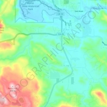
Name: Lower Lake topographic map, elevation, terrain.
Location: Lower Lake, Lake County, California, 95457, United States (38.86316 -122.65070 38.93195 -122.58551)
Average elevation: 490 m
Minimum elevation: 397 m
Maximum elevation: 759 m
Lower Lake is located 4.5 miles (7.2 km) southwest of the City of Clearlake, and 13 miles (21 km) southeast of Kelseyville. It is at an elevation of 1,371 feet (418 m). Lower Lake was at one point the county seat; the Lake County elections of 1867 were hotly contested, with the seat moving between what is now the city of Lakeport and the town of Lower Lake. In 1870, the feud was settled and Lakeport controlled the seat. Although some believe the seat was stolen from Lower Lake, it has remained in Lakeport for over a century and is no longer a topic of concern for locals. At the 2000 census, according to the United States Census Bureau, the CDP had a total area of 7.9 square miles (20 km2), of which 7.9 square miles (20 km2) was land and 0.1 square miles (0.26 km2) (0.88%) was water.
Other topographic maps
Click on a map to view its topography, its elevation and its terrain.
Clearlake Oaks
United States > California > Lake County
Clearlake Oaks, Lake County, California, 95423, United States
Average elevation: 521 m
Soda Bay
United States > California > Lake County
Soda Bay, Lake County, California, 95451, United States
Average elevation: 566 m
North Lakeport
United States > California > Lake County
North Lakeport, Lake County, California, United States
Average elevation: 427 m
Nice
United States > California > Lake County
Nice, Lake County, California, United States
Average elevation: 561 m
Lucerne
United States > California > Lake County
Lucerne, Lake County, California, 95458, United States
Average elevation: 519 m
Mount Konocti
United States > California > Lake County
Mount Konocti, Lake County, California, 95451, United States
Average elevation: 946 m
Lakeport
United States > California > Lake County
Lakeport, Lake County, California, United States
Average elevation: 417 m
Upper Lake
United States > California > Lake County
Upper Lake, Lake County, California, 95485, United States
Average elevation: 429 m
Honeymoon Cove
United States > California > Lake County
Honeymoon Cove, Lake County, California, 95443, United States
Average elevation: 408 m
Spring Valley
United States > California > Lake County
Spring Valley, Lake County, California, United States
Average elevation: 488 m
Middletown
United States > California > Lake County > Middletown
Middletown, Lake County, California, United States
Average elevation: 377 m
Hobergs
United States > California > Lake County > Cobb
Hobergs, Cobb, Lake County, California, 95426, United States
Average elevation: 874 m
Lakeport
United States > California > Lake County
Lakeport, Lake County, California, United States
Average elevation: 427 m
Hidden Valley Lake
United States > California > Lake County
Hidden Valley Lake, Lake County, California, 95467, United States
Average elevation: 389 m
Cobb
United States > California > Lake County
Cobb, Lake County, California, 95426, United States
Average elevation: 887 m
Clear Lake
United States > California > Lake County > Lakeport
Clear Lake, Lakeport, Lake County, California, 95443, United States
Average elevation: 531 m
Clearlake
United States > California > Lake County
Clearlake, Lake County, California, United States
Average elevation: 474 m
Kelseyville
United States > California > Lake County
Kelseyville, Lake County, California, 95451, United States
Average elevation: 431 m