
Texola topographic map
Interactive map
Click on the map to display elevation.
About this map
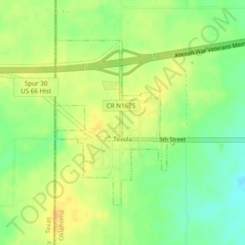
Name: Texola topographic map, elevation, terrain.
Location: Texola, Beckham County, Oklahoma, 73668, United States (35.21194 -100.00035 35.23009 -99.98273)
Average elevation: 654 m
Minimum elevation: 637 m
Maximum elevation: 667 m
Other topographic maps
Click on a map to view its topography, its elevation and its terrain.
Sweetwater
United States > Oklahoma > Beckham County
Sweetwater, Beckham County, Oklahoma, 73666, United States
Average elevation: 663 m
Erick
United States > Oklahoma > Beckham County
Erick, Beckham County, Oklahoma, 73645, United States
Average elevation: 631 m
Sayre
United States > Oklahoma > Beckham County
Sayre, Beckham County, Oklahoma, 73662, United States
Average elevation: 567 m
Sayre
United States > Oklahoma > Beckham County > Sayre > Sayre
Sayre, Beckham County, Oklahoma, 73662, United States
Average elevation: 560 m
Elk City
United States > Oklahoma > Beckham County
Elk City, Beckham County, Oklahoma, United States
Average elevation: 588 m
Sayre
United States > Oklahoma > Beckham County
Sayre, Beckham County, Oklahoma, 73662, United States
Average elevation: 567 m