
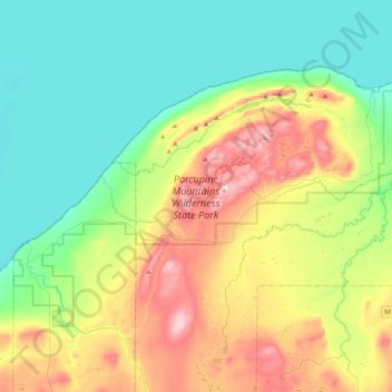
Porcupine Mountains Wilderness State Park topographic map
Interactive map
Click on the map to display elevation.
About this map
Name: Porcupine Mountains Wilderness State Park topographic map, elevation, terrain.
Average elevation: 304 m
Minimum elevation: 169 m
Maximum elevation: 589 m
The mountains are subject to heavy lake-effect snow from Lake Superior. The relatively high elevation of the mountains and their proximity to the lake provide perfect conditions for lake-effect snow, but no official records are maintained anywhere in the mountains. The closest National Weather Service station is in the coastal community of Ontonagon, where the annual average is about 200 inches (510 cm). Totals of well over 250 inches (640 cm) annually are likely in the higher elevations. It is not uncommon to have 300-inch (760 cm) seasons in this region.
Other topographic maps
Click on a map to view its topography, its elevation and its terrain.
Trout Creek
United States > Michigan > Ontonagon County
Trout Creek, Stannard Township, Ontonagon County, Michigan, United States
Average elevation: 336 m
Rockland Township
United States > Michigan > Ontonagon County
Rockland Township, Ontonagon County, Michigan, 49960, United States
Average elevation: 310 m
Ontonagon Township
United States > Michigan > Ontonagon County
Ontonagon Township, Ontonagon County, Michigan, 49953, United States
Average elevation: 238 m
Silver City
United States > Michigan > Ontonagon County
Silver City, Carp Lake Township, Ontonagon County, Michigan, United States
Average elevation: 188 m
Bruce Crossing
United States > Michigan > Ontonagon County
Bruce Crossing, Stannard Township, Ontonagon County, Michigan, 49912, United States
Average elevation: 349 m
Robbins
United States > Michigan > Ontonagon County
Robbins, Haight Township, Ontonagon County, Michigan, United States
Average elevation: 419 m
White Pine
United States > Michigan > Ontonagon County
White Pine, Carp Lake Township, Ontonagon County, Michigan, 49971, United States
Average elevation: 270 m
Bergland Township
United States > Michigan > Ontonagon County
Bergland Township, Ontonagon County, Michigan, 49910, United States
Average elevation: 407 m
Topaz
United States > Michigan > Ontonagon County
Topaz, Matchwood Township, Ontonagon County, Michigan, United States
Average elevation: 386 m