
Topaz topographic map
Interactive map
Click on the map to display elevation.
About this map
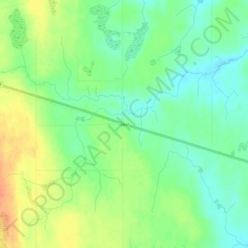
Name: Topaz topographic map, elevation, terrain.
Average elevation: 386 m
Minimum elevation: 368 m
Maximum elevation: 409 m
Other topographic maps
Click on a map to view its topography, its elevation and its terrain.
Trout Creek
United States > Michigan > Ontonagon County
Trout Creek, Stannard Township, Ontonagon County, Michigan, United States
Average elevation: 336 m
Rockland Township
United States > Michigan > Ontonagon County
Rockland Township, Ontonagon County, Michigan, 49960, United States
Average elevation: 310 m
Porcupine Mountains Wilderness State Park
United States > Michigan > Ontonagon County
Porcupine Mountains Wilderness State Park, Ontonagon Township, Ontonagon County, Michigan, 49953, United States
Average elevation: 304 m
Ontonagon Township
United States > Michigan > Ontonagon County
Ontonagon Township, Ontonagon County, Michigan, 49953, United States
Average elevation: 238 m
Silver City
United States > Michigan > Ontonagon County
Silver City, Carp Lake Township, Ontonagon County, Michigan, United States
Average elevation: 188 m
Bruce Crossing
United States > Michigan > Ontonagon County
Bruce Crossing, Stannard Township, Ontonagon County, Michigan, 49912, United States
Average elevation: 349 m
Robbins
United States > Michigan > Ontonagon County
Robbins, Haight Township, Ontonagon County, Michigan, United States
Average elevation: 419 m
White Pine
United States > Michigan > Ontonagon County
White Pine, Carp Lake Township, Ontonagon County, Michigan, 49971, United States
Average elevation: 270 m
Bergland Township
United States > Michigan > Ontonagon County
Bergland Township, Ontonagon County, Michigan, 49910, United States
Average elevation: 407 m